California’s rainy season begins with a bomb cyclone bang. Are we in for a third record wet winter?

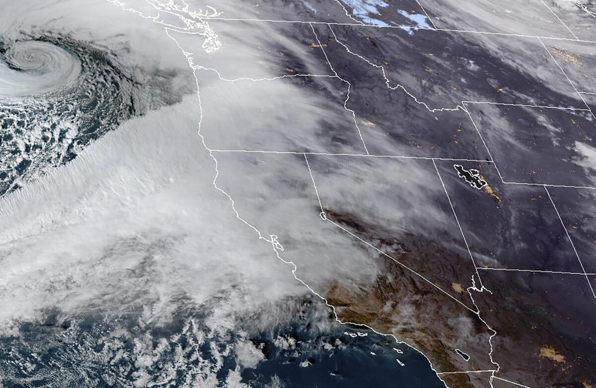
- The season’s first major atmospheric river system is pummeling much of Northern California and and the Pacific Northwest, supercharged by a bomb cyclone.
- The monster storm is kicking off California’s rainy season, but officials say it doesn’t necessarily indicate how much precipitation the rest of the winter could see.
The first major atmospheric river storm to hit the West Coast this season is kicking off the rainy season with a bang, as the system rapidly strengthened — to the tune of a bomb cyclone — before pummeling Northern California and southern Oregon with dangerous winds and heavy rains that could cause disruptions for several days.
Supercharged by that dramatic bombogenesis and warm Pacific temperatures, which together pumped up the system’s winds and moisture, the storm could cause life-threatening flooding and damaging high surf north of the Bay Area, with prolonged, heavy rainfall, strong winds and significant mountain snow, according to the National Weather Service’s Weather Prediction Center.
“Storm total rainfall may reach as high as 12 to 16 [inches], with dangerous flash flooding, rock slides, and debris flows likely,” the agency wrote in its latest forecast.
By early Wednesday, winds in the region had caused widespread power outages and some tree damage, and were expected to bring blizzard conditions throughout the Cascades, the agency said. Gusts Tuesday night hit up to 80 mph in Crescent City, according to the National Weather Service. In two separate towns outside of Seattle, two women were reportedly killed by felled trees after winds knocked out power to more than 500,000, according to electricity providers in the area.
The worst of the winds were expected across Northern California on Wednesday, though forecasters said their primary concern remained the amount and duration of the rains that were also expected to begin in earnest Wednesday.
A strong atmospheric river storm is headed for Northern California this week, bringing heavy rain, mountain snow, high winds and the potential for flooding.
By the end of the week, more than a foot of rain could drench the North Bay, where a flood watch remains in effect through at least Friday. A second low-pressure storm is forecast to interact with the first atmospheric river system, adding more precipitation that will last even longer.
“That’s going to be quite a lot of water,” said Daniel Swain, a UCLA climate scientist. These conditions are flipping much of the state “from anomalously dry to anomalously wet conditions,” he said, the latest example of California’s hydroclimate whiplash — swings that are only expected to become more sudden and dramatic as global temperatures continue to rise.
On the plus side, the significant rainfall should help most of Northern California exit fire season.
“This is welcome to a certain extent, it moves us away from fire risk by wetting down ecosystems,” said Michael Loik, a professor of environmental studies at UC Santa Cruz. “On the other hand,” he added, “it can be too much of a good thing too quickly.”
Significant rainfall isn’t expected in the Bay Area itself and points south until Friday, but forecasts are increasingly showing that much of the state will see at least some precipitation by early next week.
But it’s remains unclear what, if anything, this monster storm could indicate about the rest of California’s rainy season, though it could be the start of a brief stretch of slightly wetter weather.
Through at least the end of the month, the National Weather Service’s Climate Prediction Center forecast an increased chance for above-average rainfall across much of California, but predictions stretching into mid-December become less clear. The latest three-month outlook through January shows equal chances for above or below normal precipitation.
“It could still be a dry season relative to normal, it’s just too early to tell,” said Roger Gass, a National Weather Service meteorologist in Monterey. “It really doesn’t have a long-term indication.”
A bomb cyclone and corresponding atmospheric river are bringing precipitation to Northern California. See satellite photos and videos of the storm.
One of the only long-term predictive measures that forecasters can use, the El Niño-Southern Oscillation cycle, or ENSO, remains in neutral, meaning that the Pacific Ocean isn’t in a La Niña or El Niño cycle. Officials still think there’s a good chance La Niña will develop by the end of December; if it does, it’s likely going to be a “weak and a short duration La Niña,” according to the National Oceanic and Atmospheric Administration’s latest ENSO blog. La Niña years typically favor drier conditions for the southwestern U.S. — one of California’s last two winters that saw high precipitation was an El Niño year — but a weaker cycle means its influence can also be minimized.
The Mountain Fire burned about a quarter of Ventura county’s avocado harvest. The county is the number one producer of the fruit in the state.
“Historically, during these weak La Niñas we have seen slightly less rain than normal,” said Bryan Lewis, a National Weather Service meteorologist in Oxnard. “It’s hard to say that will continue for this period, but it does look like the next week or so we’ll have these periods of rain.”
Lewis said there appears to be the possibility for another low pressure system that could affect California by Thanksgiving weekend, but it’s too early to know where or how much rain that could bring. And he noted that a short string of storms isn’t enough to indicate what the whole winter could bring.
But water officials are taking what they can get with this storm, noting that the state remains below average for precipitation this water year (the 12-month period that started Oct. 1) after a hot and dry fall, according to California Water Watch.
“The rainfall that will occur over the next several days will be extremely beneficial for California’s snowpack later in the spring and summer of 2025,” David Rizzardo, manager of California’s Department of Water Resources Hydrology Section, said in a statement. “For California to benefit from snowmelt in the spring and summer, we need good rainstorms in the fall and early winter to wet the soils in the mountains so that more snowmelt in the spring or summer results in runoff and is not lost to the soils.”
A flood watch remains in effect through late Friday across the North Bay, where some higher elevations could see up to 10 inches by Thursday, the weather service warned. On top of that, an additional 2 to 4 inches of rainfall could fall Friday and Saturday. Much of Mendocino and Lake counties, as well as parts of the Sacramento Valley, are also under a flood watch through Friday, with concerns about “prolonged periods of moderate to heavy rain,” the weather service warned.
Mountains across Northern California, including in Shasta County and across the Sierra Nevada, could see up to 20 inches of snow at elevations above 4,500 feet, with some areas getting up to 4 feet Wednesday, according to the winter storm warning for the area.
In Southern California, the chances for major rainfall have been steadily increasing, with forecasters now confident that the region could see measurable rainfall beginning this weekend and into early next week as the storm slides southward.
“We’re thinking it’s going to be more of a beneficial rain,” Lewis said, noting that it could help ease some fire concerns, but likely not eliminate those worries entirely.
More to Read
Sign up for Essential California
The most important California stories and recommendations in your inbox every morning.
You may occasionally receive promotional content from the Los Angeles Times.


